Disaster recovery
These could be seismic or microwave devices to detect
earthquakes or landslips, temperature or CO/CO2 to detect
fires, and water-level sensors to warn of floods. Providing
backhaul to sensors in very remote areas can be done
through satellites. Iridium offers Cloudconnect to link static
or mobile IoT sensors into Amazon Web Services, and in
the context of disaster operations, remote sensors can remain
in touch and critical assets such as mobile lifting or medical
units can be tracked. Inmarsat offers a similar service.
Drones and airships
Korea Telecom (KT) has developed a combined system
using an airship which carries small drones to provide search
and rescue communications. At a demonstration featuring a
simulated rescue, the airship located the victim, and a local
911 response team was assisted by AR eyewear. Information
from the scene was shared with a surgeon, who assessed the
health of the patient and recommended remote treatments.
The system adds a mobile ground control station, as well
as Skyscan, which detects smartphone signals to combine
them with a database to provide information on victims and
survivors. Skyscan uses a small LTE device to locate survivors
with a 50-metre radius, and small drones can then precisely
locate them for rescue crews.
Drones can be especially useful in reaching isolated
areas when low cloud (or the cost) makes manned aircraft
operation impossible. Following the Oso, Washington
mudslide in 2014, a drone was used to map the state of the
terrain. It is also possible to make use of hobby drones in
these situations, but they need to be co-ordinated so as not
to interfere with operations, as has sometimes happened.
The role of AI
Can AI anticipate events and speed up response? The
Microsoft Azure cloud-based environment includes AI
platforms that can monitor weather stations, and seismic
and heat sensors on trees to predict storms, earthquakes and
forest fires. Early warnings help give the public time to react.
At a local level, IoT sensors can allow controllers to
monitor transport, power and buildings to direct resources;
AI will lighten the load and provide alternative routes and
warnings of failures. Agencies can apply AI and machine
learning to data to predict disaster impacts, so they can plan
staging areas, evacuation routes and flood areas. Historic data
from sources such as the National Oceanic and Atmospheric
Administration (NOAA) in the USA
have been used to build predictive models for likely flooding
areas and the damage that may occur. Could AI be used to
predict damage to communications systems during severe
weather (loss of towers) or earthquakes and floods (loss of
landline links)?
Social media is another promising area for the use of AI.
During the Mexico City earthquake of 2017, AI was used
to alert volunteers to assist in life-saving activities. Rescue
missions were crowdsourced, including requests for items and
assistance, which were passed to volunteer groups.
Using today’s resources more effectively
Manufacturers of secure communications systems such as
P25 and TETRA can make a significant contribution during
disasters. Motorola Solutions in North America has response
teams that assist public agencies during emergencies, such
as during Hurricane Michael in October 2018. As well as
hitting Florida, the hurricane moved through Georgia and
Alabama, destroying infrastructure including cell towers.
Robert Marshall, VP southeast region for Motorola Solutions,
says: “We worked closely with state and local authorities
to prioritise and co-ordinate repair efforts. As a result, we
were immediately able to restore systems that were directly
in Hurricane Michael’s path in Lee County, Georgia and
Bay County, Florida, including the Tyndall Air Force Base.”
Motorola Solutions notes that even though some P25 towers
were destroyed, direct mode still connected officers during
and after the storm. Manufacturers can assist with the loan
of handsets to volunteers, as was the case in Butte County,
California in November 2018, when Motorola Solutions
supplied 200 P25 radios to response teams dealing with the
Camp Fire emergency.
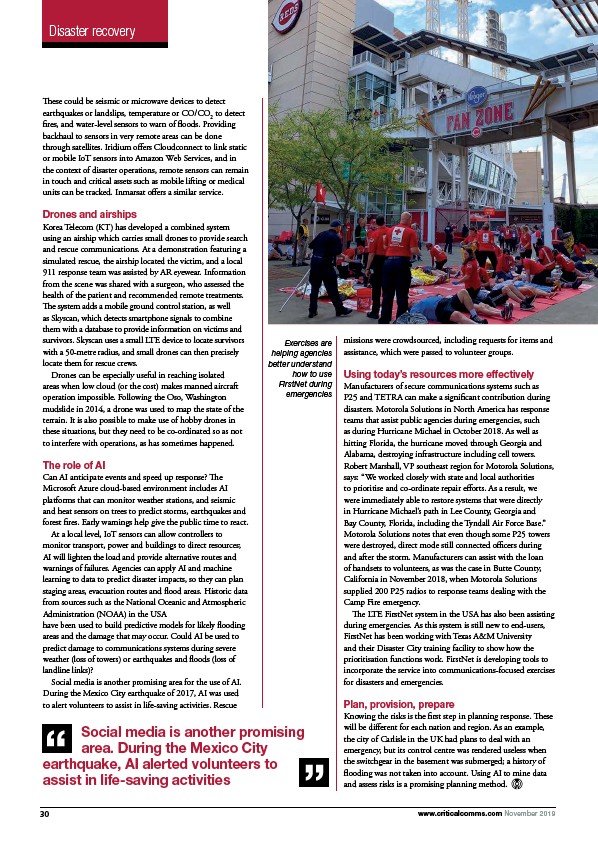
The LTE FirstNet system in the USA has also been assisting
during emergencies. As this system is still new to end-users,
FirstNet has been working with Texas A&M University
and their Disaster City training facility to show how the
prioritisation functions work. FirstNet is developing tools to
incorporate the service into communications-focused exercises
for disasters and emergencies.
Plan, provision, prepare
Knowing the risks is the first step in planning response. These
will be different for each nation and region. As an example,
the city of Carlisle in the UK had plans to deal with an
emergency, but its control centre was rendered useless when
the switchgear in the basement was submerged; a history of
flooding was not taken into account. Using AI to mine data
and assess risks is a promising planning method.
Exercises are
helping agencies
better understand
how to use
FirstNet during
emergencies
Social media is another promising
area. During the Mexico City
earthquake, AI alerted volunteers to
assist in life-saving activities
30 www.criticalcomms.com November 2019
/www.criticalcomms.com